When we think of old roads, tracks, byways, we naturally tend to visualize solid ground. Yet there are far earlier roads, known and followed by travelers since prehistoric times. The great river roads connecting Ireland’s interior to the sea were easier to navigate and often safer. No need to beat through thick forests where enemies or wild animals might lurk, no danger of losing your way. Jo Kerrigan takes us along the Shannon River Road.
The longest river in Ireland and indeed longer than any in neighboring Great Britain, the Shannon rises from a dark and mysterious pool in County Cavan and flows south and west for 360km (224 miles) through or between eleven counties before reaching its estuary, which is itself a major harbor. Virtually dividing Ireland in half, it’s our supreme waterway, known and traveled for thousands of years. It has seen invaders, pilgrims, colonizers, battle fleets, engineers, industrialists, and, finally, pleasure-seeking tourists. As such, it is linked to every stage of Ireland’s history and development.
Whoever first happened upon its spreading estuary must have wondered what could possibly lie further inland, since from the sea it is not possible to guess just how far the wide waters continue. What we do know is that it was familiar to the world’s earliest traders. It is shown on Ptolemy’s famous 2nd-century map, which was itself compiled from earlier sources held in the legendary library of Alexandria in Egypt.
Alexandria was an important trading center at the crossroads between the West and the East. The Pharaohs gently but firmly insisted that any books or writings arriving with travelers should be confiscated and copied for their library.
In fact, the originals were kept by the Pharaohs, while the travelers received the copy. The great library became a treasure house of knowledge, and Ptolemy would thus have gathered his information on Ireland from sources such as nautical charts and descriptions of journeys, which themselves originated from information passed between trading ships over previous centuries. We can be pretty sure, therefore, that a good knowledge of Ireland’s coastline and its major rivers was available from before the time of Christ. And that, in turn, argues a succession of visitors to these shores, whether traders or travelers, from a long way back.
What did they come for – trade, raid, worship, or settlement? The trade route from Iberia to Ireland and Great Britain stretches back into prehistory. Ships from the Middle Sea or the Mediterranean would have brought wine and salt north, exchanging it for hides, wool, grain, and copper. They, in turn, dealt with the Greeks and Phoenicians, and it is pretty likely that these traders from the far south also came to Ireland. From the north, the Danes brought tar and timber, seeking foodstuffs and hides in return. Later, they would return in their longships to plunder, terrorize, and finally settle.
Then there were pre-Christian pilgrims who might well have made the long journey to visit famous sacred sites like the Hill of Uisneach, using the river roads to reach them. And finally, there were those seeking new lands, somewhere to settle, found a community, raise families, and crops. Many came to the estuary of the Shannon.


Hill of Uisneach.
This river has always been of strategic importance. When Oliver Cromwell ravaged the country in 1654, his principal aim was to ethnically cleanse three of the four provinces to free up the land for incoming English settlers. Any surviving landowners were given the choice of going ‘to Hell or to Connacht’; that is, die or migrate into the poorer land west of the Shannon.
Approaching from the sea, the Shannon estuary appears enormous, as indeed it is, with County Limerick spreading out on the southern side and County Clare to the north. The estuary has boasted its own river monster since ancient times, a fearsome creature called Cathaigh, which sported a horse’s mane, a whale’s tail, and death-dealing nails of iron.
St Senan, patron saint of County Clare, is said to have defeated Cathaigh at Inis Cathaigh, or Scattery Island, which lies in the estuary just outside Kilrush. You can’t keep a good monster down, though, and she might still be spotted on stormy days if you keep your eyes open. Senan afterward founded a monastery on the island, the ruins of which still stand, along with a round tower.

An aerial view of Kilrush, County Clare.
Catch a ferry there from Kilrush and enjoy the peace that now envelops an islet that has seen Viking raiders, sheltering Spanish Armada ships, Tudor invaders, and even more recent British army outposts. An island in such an estuary is a key strategic location, whatever the century.
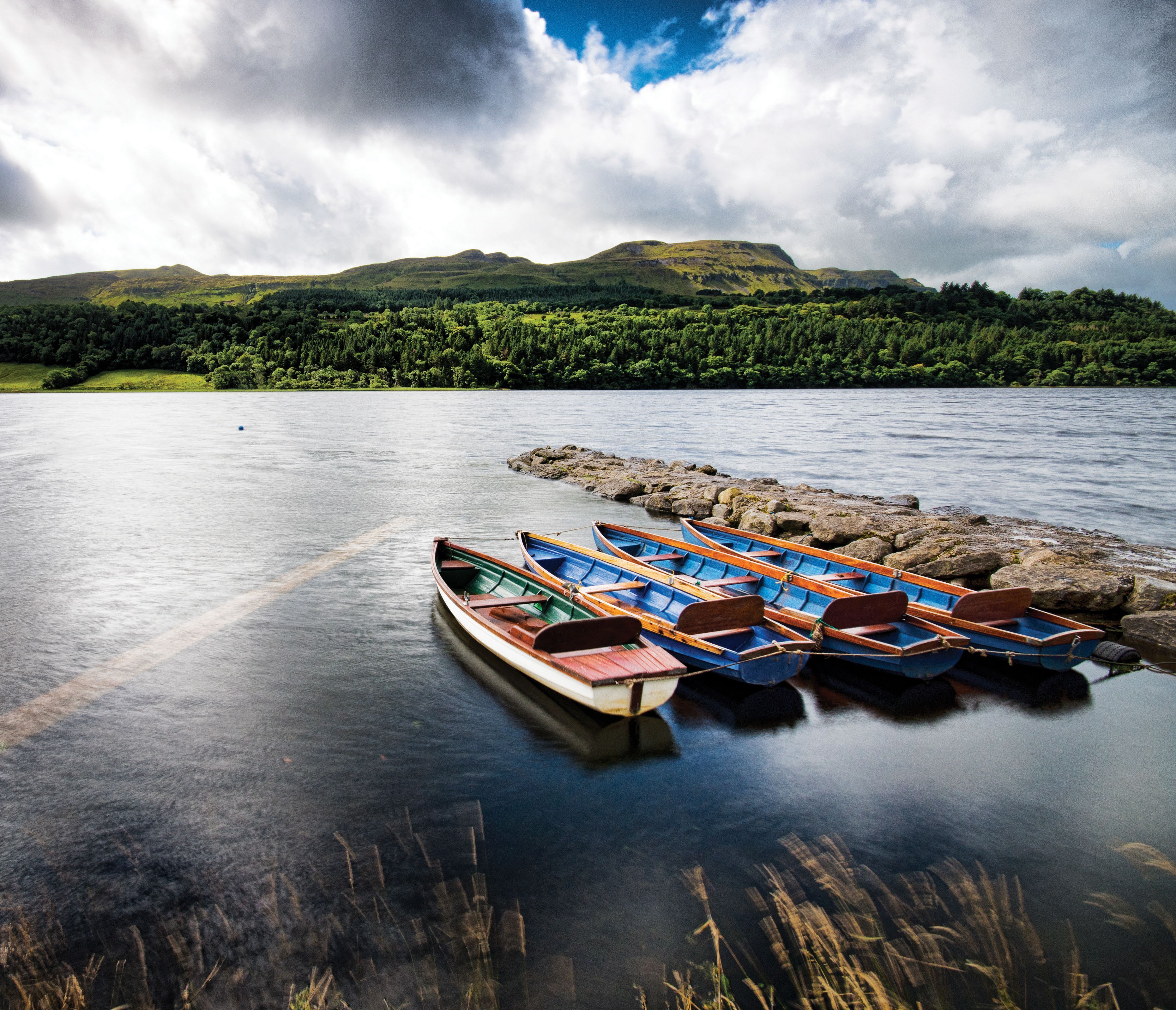
A short distance upriver from Scattery, the estuary narrows a little, and here a modern car ferry crosses between Killimer and Tarbert, reflecting thousands of years of boat travel, transporting travelers from one side to the other. The name Tarbert, or Tairbeart, means a draw-boat or portage, that is, a place where boats must be pulled across land to reach another stretch of water. The ferry port is, in fact, on a little island just off the mainland, although it is now connected by a bridge. In early times, those crossing the estuary at this narrower point might well have had to drag their boats across the narrow island before reaching the Limerick shore. The car ferry is an ideal way to experience the space, the grandeur, the wildness of this great river as it meets the sea. Dolphins are often spotted disporting themselves around the boats (they really seem to enjoy accompanying them).

Shannon Ferries, from Killimer.
Foynes, on the Limerick side, was the first landing base in Ireland for seaplanes or flying boats from North America. Charles Lindbergh made surveys in the early 1930s, and the first transatlantic flight from Newfoundland landed there in 1937. In 1942, Foynes was abandoned in favor of a new airport at Shannon. Today it houses a museum of flying boat history.

Foynes Island viewpoint, County Limerick.
The distinctive fishtail shape of the upper estuary becomes noticeable here, the River Fergus forming the north fin, and leading on to Newmarket-on-Fergus, Clarecastle, and Ennis. The southern fin of the fishtail is the Shannon itself.
The flat landscape we see today around the Shannon estuary was far more thickly wooded in antiquity. Archaeological digs, as well as occasional marked drops in sea level, have revealed the remains of coastal forests, trackways, and wooden dwellings. The remains of woven willow fish baskets and fish traps have been found, and the medieval Annals of Innisfallen record that in 1105 ‘…there was caught by fishermen in the sea of Luimneach [Limerick] a fish of unheard-of size which measured fifteen feet, and two ingots’ weight were obtained for it.’ Was it a basking shark? A pilot whale? Or perhaps one of Cathaigh’s offspring, escaped from St Senan’s clutches?
Lough Gur, 22km (13.6 miles) south of Limerick, was probably settled by migrants arriving via the rivers Shannon and Maigue some 6,000 years ago. Today’s site has been reconstructed to give an idea of what life was like in the Stone, Bronze, Iron, Early Christian, and medieval eras. About 300m (330 yds) west of the main center is the largest stone circle in Ireland, Grange, built around 2,200 BC. The largest of its 113 standing stones is known as Crom Dubh, after an early pagan harvest god.

Lough Gur, Co. Limerick.
Bunratty Castle, on the Clare side of the Shannon, is a tourist magnet, offering everything from medieval castle banquets and shopping to a folk museum. The Vikings got here first, though, creating a settlement in the 10th century on high ground, giving them an extensive view south over the estuary. That strategic position was not lost on the Anglo-Normans either: they established a medieval town on the same spot. By 1287, this had a population of about 1,000 people and boasted a castle, a court, a shambles (meat market), fairs, a water mill, a fish pond, and a rabbit warren. One 14th-century Irish text refers to ‘Bunratty of the wide roads, oared galleys and safe harbor.’

Bunratty Castle.
On the other side of the Shannon, lies the thriving city of Limerick. It was founded by the Vikings, who discovered a handy island there in 812 to set up camp. Today, known as King’s Island, this is hardly distinguishable as a separate entity from the rest of the city when driving through, but keep a sharp eye out when heading for King John’s Castle, and you will see that you have to cross the smaller River Abbey en route. The Abbey is a distributary rather than a tributary, as it forks off from the Shannon a little way upriver and then joins it again near the old Potato Market. One might well think that the island got its name from the castle, but in fact, the 2nd-century Ptolemy map mentioned earlier shows a place called Regia (i.e., King) in precisely the same spot, indicating a much earlier royal settlement. That wouldn’t be surprising, since it’s a natural river crossing and a good defensive position.

Limerick city.
The Viking sea-king Thormodr Helgason used this island base to range up and down the Shannon from Lough Derg to Lough Ree, snatching treasures from monasteries and abbeys along the way. The Limerick raiders, however, met their match in 937 when they clashed with their Dublin counterparts on Lough Ree and were thoroughly defeated.

Lough Ree.
In Norman times, the walled city on King’s Island was known as Englishtown, to distinguish it from Irishtown, which was kept firmly south of the Abbey river and thus off the island. King John’s Castle was built here in 1200 and is one of the best-preserved examples of its kind in Europe. Close by, St Mary’s Cathedral, founded in 1168, is the city's oldest structure still in daily use. Some five centuries later, the Treaty of Limerick was signed here on a block of limestone, ending the war between the Jacobites and the Williamites.
Killaloe, upstream from Limerick, lies on the southern shore of Lough Derg and the west side of the Shannon, with Ballina directly across on the eastern coast. It’s another one of the principal crossings of this major river road, and as such is rich in history and archaeological discoveries. In St Flannan’s Cathedral is a unique stone bearing both Viking runes and ogham. The runes read ‘Thorgrim carved this stone’ while the ogham records ‘A blessing upon Thorgrim.’

Killaloe.
Killaloe is the birthplace of the High King, Brian Boru, who ruled his kingdom from here before meeting his death at the Battle of Clontarf in 1014. There are two claims for his ancestral home. The first was Kincora, or Ceann Coradh, meaning ‘head of the weir,’ a castle that stood on a hill above what is now Killaloe town. Unfortunately, nothing remains of that ancient royal stronghold. The second site, fortunately, is still with us.
Brian Boru’s Fort is a circular earthwork standing on a spur of land overlooking the point where Lough Derg narrows into the Shannon. It is also known as Béal Bóru, or ‘port of the cattle tribute’, indicating that a toll was levied on goods and animals using this crossing, or alternatively, that tributes were paid here to a ruler. Whoever controlled this fording point controlled the strong trade route from the coast into the heart of the country.

Lough Derg.
A short walk down from the road leading north from Killaloe town brings you to the vast and silent tree-ringed fort, which must have been a hive of activity in the days when it was a royal seat. The king would never have allowed the magnificent surrounding trees to grow to their present height, as it would have interfered with the watchmen's ability to keep a sharp eye out in all directions.
The ringfort actually dates from an earlier period than that of Brian Boru. More than 800 stone implements, including stone axes, hammerstones and perforated stone sinkers for lines and nets, have been found in this area, and many stone axes within the fort itself. This suggests that a Stone Age settlement occupied the site because of its position at a convenient fording point, which could also serve as a safe harbor for small boats used for fishing. It was undoubtedly an excellent strategic spot and one from which the king could sally forth at speed either along Lough Derg or along the river, depending on where the trouble was brewing.
At one time, Brian Boru had a fleet of 300 ships on the Shannon and harried the King of Tara, Mael Sechnaill, right up to his sacred site of Uisneach, modern County Westmeath, in pursuit of his own claim to the high kingship. He also went downriver and attacked the Viking settlement at Limerick, causing its leaders to seek refuge on Scattery Island. That didn’t help them, as Brian followed them there, even into the sanctuary of the church, and slaughtered as many as he could find. Perhaps the fact that, as a child, he had seen his own mother killed by invading Norsemen gave him a particular lust for revenge. An excellent 11th-century sword was found in Lough Derg in 1988, made of iron with silver and copper decoration. It could well have been used by Brian Boru himself or one of his commanders. It is now in the National Museum in Dublin.
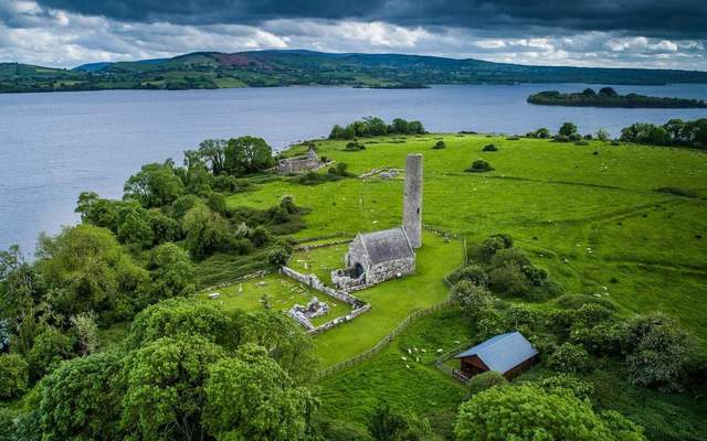
Holy Island, or Inis Cealtra, on the same lough, is an old monastic site with a round tower, many church ruins, a sacred well, and a graveyard dating back to the 8th century. There is also a bargaining or covenanting stone, where marriages or bargains could be agreed. It is likely that this islet was already a sacred site in pagan times, which encouraged the incoming Christian religion to found a center of their own here.

Holy Island, or Inis Cealtra.
The Irish name for Nenagh, a few km to the east of Lough Derg, is An t’Aonach, or The Fair. Since it lies on the River Nenagh, which flows into the lough and thus connects to both the north and the south by river road, such a location would have been a natural choice for traders and the establishment of a town.
Extract from "Follow the Old Road" by Jo Kerrigan with photography by Richard Mills is published by O’Brien Press and is available from www.obrien.ie.
* Originally published in 2021, updated in December 2025.
Comments