
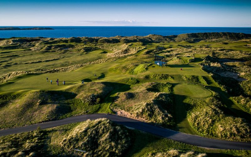
Irish Air Corp patrol Ireland on average 300 times a year and happily for us they use their unique skills and equipment to take these stunning photos of the island's landscapes
The Irish Air Corps, part of the Defence Forces of Ireland, run, on average, 300 patrols over Ireland every year. Armed with unique skills and scientific instruments the flight crews have captured some beautiful aerial shots of Ireland, which they share with the public via social media.
“Luckily for us, our patrol zones not only contain some of the most productive fishing areas but also some of the most majestic scenery in the world,” said Captain Brendan O’Dowd, Air Corps Press & Information Officer, and aircraft Captain on the CASA CN235, the maritime patrol aircraft.
“As we transit around from vessel to vessel we sometimes get to see the best the Irish coast has to offer and the photographs we have been sharing have been opportune photographs taken by our crews as they go about their routine taskings.”
O’Dowd explained to IrishCentral that the Air Corps is tasked with patrolling Irish waters, an area of approximately 132,000 square miles (16 percent of the EU’s sea fisheries), a region five times the land area of the island of Ireland.
During these patrols, they monitor all activity of fishing vessels, pleasure craft and merchant ships for illegal or suspicious activity. The aircraft are kitted out with extremely modern and sophisticated radar and sensor equipment, which allows them to identify objects in the water from vessels to whales from up to 200 miles away.
“The aircraft are crewed by two pilots, two radar operators, a radio signaler and a photographer for these missions, which last on average six hours,” explained O’Dowd.
“Together they document the activity seen with the photographer’s camera, which is linked to the mission equipment, and create a strong evidence chain so if illegal activity is spotted a prosecution can be made at a later date.”
Photos - Aerial photos of Ireland from the Air Corps
“The photographers from these missions are all soldiers from the Air Corps 105 Squadron. They have all been trained by the Air Corps, where the technical skills of the unit's photographers have been passed from generation to generation,” O’Dowd told IrishCentral.
When asked what stunning vista really stick out in his mind O’Dowd was stuck for an answer. He said, “It’s a very hard question to answer. The beauty and ruggedness of the west coast of Ireland is so immense it’s hard to name just one area. Starting at the most southern tip of Mizen Head you have the beautiful peninsulas of West Cork and Kerry, which contain some amazing sights like the ring of Kerry, the World Heritage site of the Skellig Islands and the famous Blasket Islands off the coast of Dingle.
“Only miles to the north lies the rocky expanse of the Burren, which leads, in turn, to the majestic Cliffs of Moher. Another few miles takes you to the breath-taking cliff fort of Dun Aonghus on the Aran Islands or the sunken drumlins of Clew Bay, which lie in the shadow of Croagh Patrick.
“Every mile along the coast has another hidden treasure and we are so lucky that we get to see these amazing sights every day from the comfort of our office.”
Capt. O’Dowd said that there are no plans for an exhibition but added that the Defence Forces are constantly exploring different ways of sharing the amazing sights and activities they get to see with the public.
He added, “Hopefully there could be something in the future.”
For more visit the Air Corps Facebook page here.
Photos - Aerial photos of Ireland from the Air Corps

Comments