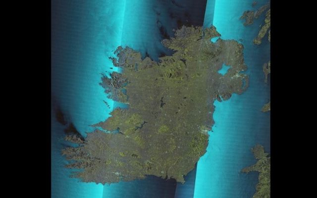
A British satellite has created a stunning map of Ireland and the United Kingdom using state-of-the-art radar technology.
Surrey Satellite Technology Limited's (SSTL) NovaSar-1 Satellite, which pictures the Earth's surface using radar, created the image in just seven passes.
The satellite can detect the ground even when it's dark or when there is thick cloud cover, meaning that it can work far quicker than a traditional optical satellite, which would require significantly more time to complete the image.
The original image is about two gigabytes and includes some incredible details, including bridges, lakes, parklands, mountains, and ships.
Each pixel on the map represents a 50-meter square on the ground, while it is also possible to see wind turbines at sea, even though they are well short of being 50 meters wide.
Wind turbine towers have hard, metallic surfaces that reflect radar energy, meaning that they show up as brilliant specks on the map.
SSTL says that the image shows Ocean Surface roughness variations, especially off the west coast of Ireland.
Information on the map can be used to study land uses such as the changing urban footprint in Britain and Ireland in addition to the types of crops being grown on agricultural land.
Sharing a fantastic radar image of the UK acquired by SSTL's NovaSAR-1 from 7 images - view/download via our website https://t.co/w1ndnlCeCp @AirbusSpace @spacegovuk @SatAppsCatapult pic.twitter.com/OlgtTbqhfL
— Surrey Satellites (@SurreySat) January 19, 2022
Andrew Cawthorne, the director of Earth observation at SSTL, which built the NovaSar Satellite, said that the satellite was able to capture complete images regardless of external influences.
"You know that when you pass overhead, you're going to get an image without any external influences causing you problems," Cawthorne told the BBC.
The satellite was designed and built in the United Kingdom thanks to £21 million in seed funding from the UK Space Agency. It is the only sovereign radar system that the UK has.


Comments