An interactive map of Cork City, which allows visitors to scroll through centuries of the city's history, is now available for free online.
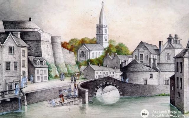
The Digital Atlas of Cork/Corcaigh showcases 6,245 sites of Cork City’s history, including buildings, streets, bridges and monuments, from AD 623 through to 1900.
Launched by the Irish Historic Towns Atlas (IHTA) and the Royal Irish Academy, the digital atlas includes descriptions of over 800 streets, including their names in Irish and English as well as historical variants. Users can browse the digital atlas or search for a specific site in the city. They can also select and view features associated with specific time periods, from medieval times to the present day.
The Digital Atlas of Cork/Corcaigh includes a specially commissioned historical map depicting each individual house and plot during the mid-nineteenth century (1842). This is just one of a number of layered maps that may be switched on and off to show how the city developed over 200 years.
Other layers include Ordnance Survey maps — a present-day plan of the city, as well as historic maps showing Cork pre-Famine and at the turn of the twentieth century.
The Digital Atlas of Cork/Corcaigh will be of interest to a wide range of individuals from the ‘rebel city’ and beyond, including students of all levels and their teachers, researchers and planners.
"The research and further reading aspect of the atlas will be a terrific source for anyone with an interest in the history and development of Cork City," said Councillor Kieran McCarthy, Lord Mayor of Cork City.
A downloadable user guide has also been created to accompany the resource, to allow anyone to explore the Digital Atlas with further education and project work in mind.
“The Digital Atlas of Cork/Corcaigh will greatly facilitate easy access to the rich array of source materials for understanding the evolution of Cork," said Virginia Teehan, Chief Executive, The Heritage Council.
"The Heritage Council is very pleased to support this work and congratulates the Irish Historic Towns Atlas, Royal Irish Academy and partners Cork City Council, Digital Repository of Ireland, Tailte Éireann and the National Archives of Ireland for bringing this to fruition.”
Ciara Brett, City Archaeologist, Cork City Council said: “The Cork/Corcaigh Digital Atlas, when utilised with the forthcoming printed Atlas, will be a great benefit to the study of the changing urban environment and will provide practical assistance in the preparation and implementation of planning policy and development management in the city.
"The IHTA Cork/Corcaigh volume in digital format will add to the existing corpus of published material and will, I believe, encourage future research and study that will enhance our understanding and appreciation of our city.”
The Digital Atlas of Cork/Corcaigh can be accessed online through the Royal Irish Academy’s website here.
Comments