
The RMS Lusitania has been recreated in 3D in a bid to ultimately protect it as an official heritage site.
The vessel sank during the First World War after it was torpedoed while traveling from New York City to Liverpool. Almost 1,200 people on board were killed in the incident.
Cunard’s Lusitania has now been recreated in 3D alongside hundreds of other vessels submerged in Ireland’s territorial waters.
Scientists used sonar technology to recreate the ill-fated vessel near Kinsale, County Cork. The Daily Mail reports that a total of 360 ships have already been identified and recorded as part of the project.
Efforts to map the coastal waters around Ireland in a bid to learn more about the vessels’ locations and dimensions began in 1996 and are set for completion in 2026.
Read more: Why do we care about the Titanic more than the Lusitania?
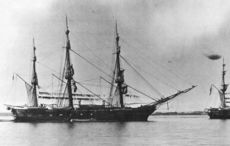
RMS Lusitania New York - 1907. See more photos here: https://t.co/F8i7vXsi2B pic.twitter.com/mtVjZkJM1A
— History Lovers Club (@historylvrsclub) November 16, 2018
As part of the project from the Marine Institute (MI) and Geological Survey Ireland (GSI) - limits were placed on who could access the ship wrecks. In fact, only archaeological divers who applied to the Irish government for specific licenses could get close to the sites.
Once finished, the MI and GSI hope the project will aid the enforcement of official heritage orders used to preserve maritime remains dating back more than 100 years. Sites are often filled with not only valuable goods but human remains.
“Before the National Monuments Act 1930, any amateur diver could find a wreckage and essentially claim it as their own,” marine geologist Charise McKeon of GSI told the Daily Mail.
“We work in tandem with the National monument service and, by getting these 3D scans, it helps them to identify which sites are deemed of national importance and worthy of protection.”
RMS Lusitania - built by John Brown and Company, Clydebank. Sunk on 7 May 1915 by a German U-boat. pic.twitter.com/hTBnx15fsL
— PictureThis Scotland (@74frankfurt) November 11, 2018
“We use a whole fleet of marine vessels and a hull, mounted directly underneath a vessel with multi-beam echo sonars that send sound down the seabed,” says Maria Judge from GSI.
“That builds a very smooth three-dimensional image of the seabed. Another aspect of the mapping of our seabed is we get to see extraordinary features — it’s not just deep, dark, wet and flat down there,” she added.
“We began mapping the late 1990s and we’re still mapping now. It does take an extraordinary amount of time.”
Read More: Pirates diving and looting the wreckage of the RMS Lusitania
Read More: American businessman to donate Lusitania artifacts to Ireland


Comments