Tthe Nire Valley in the heart of the Comeragh Mountains goes nowhere else... and the area is filled with treasures for its visitors.
Most of the roads in Ireland go to meet other roads. But the byway to the Nire Valley in the heart of the Comeragh Mountains goes nowhere else. People spend days wandering around these beautiful hills – but the valley also makes a very good base for discovering exciting parts of neighboring counties of Tipperary and Waterford. Our route takes a day and a half to explore the seaside, mountains and the historic towns that go with them. Having set out from Dublin we started circuit in Clonmel but people coming from southern ports could begin by the seaside in Dungarvan Ardmore.

Main Guard, Clonmel (Munster Mountains)
Clonmel is clearly signposted from M9 motorway. An ancient town with an ancient street layout, the best way of visiting it is to make your way to one of the riverside car parks – and walk. What makes it especially exciting is the survival of a substantial piece of the 15th-century town walls together with a selection of buildings from most of the centuries in between. And it’s a thriving, busy bustling town with a peaceful riverside walk and a view to the south to the mountains.
The highlights are clustered around the center within old walls and you don’t have to be especially energetic to find them. In particular look out for the 17th century Main Guard, which houses a helpful Tourist Office, the 14th-century town walls with their restored West Gate and rebuilt Franciscan church which contains brilliant modern stained glass and a particularly fine 15th-century effigy.

Comeragh Mountains view (Munster Mountains).
The old town was built entirely on the left bank of River Suir but it spread southwards across the water in the 19th century. Take most downstream of three bridges that cross it and follow the R678 road which takes you high up into Comeragh Mountains. Four miles out of town look for a signpost which encourages you to go even higher and find the way to Hanora’s Cottage. It is the second of two such signposts. Both lead to wonderful hilltop roads, but the second is even more wonderful than first. They take you into the very heart of the mountains, past sheep at pasture and then through heather moorland before going downhill again into the Nire Valley.
You meet the River Nire and cross it by a black-and-white bridge at bottom of the hill. Then turn left and re-cross the river over a beautiful old two-arched stone bridge, overlooked by a guest house called Hanora’s Cottage and a church built in 1861 from same honey-coloured local stone as bridge displays. We made Hanora’s Cottage our base – it is a most delightfully welcoming establishment with rooms far beyond the normal level of comfort – each has its own Jacuzzi. The proprietor Mary Walls happily imparts her prodigious knowledge of the region to all and is full of ideas and advice on how to enjoy it.

West Gate, Clonmel (Munster Mountains)
The cottage and church are set in a narrow part of the valley, in the shadow of Shauneenabreaga Mountain and they look at first glance as if they are at end of the road. And so they are in a way because it is the only way for cars to enter or leave higher parts. But in fact, it goes on for another mile and a half and valley, surprisingly, instead of growing steeper and narrower opens out into a prosperous landscape of green pasture, hedges and farmhouses. The road ends at a car park and an enticing foot-path which goes through heather over Knockanafrin – Mountain of Mass – and down another side to Rathgormuck.

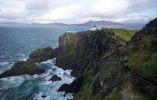
Helvick Fenian Memorial (Munster Mountains).
But we were not so enticed and turned back down the valley in search of the seaside. The mountain road leads to the village of Ballymacarbry where a left turn brings you on to the road for Dungarvan. This ancient seaport lies at the head of an immense shallow bay where tide falls to reveal sand flats spreading for miles. Like Clonmel, it is a place to park your car and walk around. There is a castle claiming to be a foundation of 13th century King John of England and a 17th-century market house.
Take the coast road from Dungarvan for two miles and then turn left to find the village of Ring and little harbor of Helvick Head. Ringville, officially An Rinn, is the center of a remarkable outlying area of Gaelteacht, where Irish survived as a living language and remains preferred means of communication of many people, both old and young. It houses Irish-speaking schools and enjoys a great influx of students attending summer courses. Farther out is the remote headland of Helvick with its busy little fishing harbor and a stone obelisk commemorating heroes of Fenian Rising of 1867.

Mountains of Munster - Route Map.
Retrace your drive from Helvick though Ringville and turn left for Ardmore when you meet N25 – a good road that gives fine views of the mountains to the north and sea to the south as it makes its way to Youghal. But we don’t go that far, turning to the south after five miles for our last close look at the seaside at Ardmore ‘big hill’.
Signposts to the left take you to pleasant beaches from which you can look up towards the said hill and admire the splendid round tower that has stood there for eight hundred years. That may not be much for a round tower since most of them are a couple of centuries older. But Ardmore is special, both in its refined architecture and in marking a spot of unusual interest in the history of Christian Ireland. Everybody knows that St. Patrick spread the faith throughout Ireland. Not so many are aware that St. Declan had established a Christian community at Ardmore before the arrival of Patrick. Below tower you may visit a little stone oratory, said to be the burial place of Declan and, nearby, extensive ruins of a big church, richly decorated with Romanesque carving and presenting a unique collection of 10th-century relief sculptures showing scenes from scriptures.

Ardmore Round Tower (Munster Mountains)
From Ardmore stay on the main road as far as Lemybrien, then turn left at crossroads and head westwards towards the Monavullagh Mountains. Follow signposts for Mahon Falls and embark on an exceedingly narrow road that takes you uphill first through green fields and then through more and more barren and stony hillsides to a car-park. The view is of a thin white ribbon of water that seems to come down from skies as water cascades from Knockaunapeebra – Piper’s Hill.
The narrow road goes in a circle and takes you back towards Lemybrien. Turn left when you meet R676. If you follow it into the valley of River Suir you will end up in the small town of Carrick and access to main roads that take you away from mountains. But a left turn at crossroads in direction of Clonmel takes you over Comeraghs once more and mountain road that brought us to Nire Valley in the first place.

Mountains of Munster - Route distances


Comments