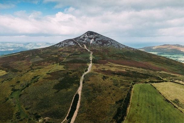
Living and working in Dublin’s city center it is easy to forget what a small and beautiful island Ireland really is. Just a 50-minute drive from the GPO is The Great Sugarloaf, a 501-meter-high mountain with 360° views stretching from north Dublin to Wicklow, and beyond.
So it was on a gloriously sunny Bank Holiday that three Dubs took off to stretch their legs and blow away the cobwebs.
Located in Co Wicklow, nicknamed “The Garden of Ireland,” the hiking trails of The Sugarloaf Loop Trail are just off the N11 dual carriageway road, close to the picturesque villages of Kilmacanoge and Enniskerry.
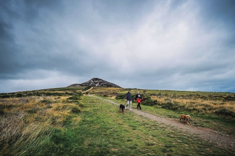
While the Sugarloaf might not quite be a mountain, you should be warned that it is windy up there and there is a fair bit of “climbing” (using hands and feet to get to the summit). But wow, once you get up there the view will not disappoint.
The Great Sugarloaf offers two hiking routes: one for novices and one for more experienced hikers. We took the shorter walking trail which takes about an hour but is in no way unchallenging. Although I am loath to admit it, we were lapped by a little boy of five years of age among other children. The walk starts from the car park to the south of the mountain and leads up the clearly marked path.
The longer walk, should take about 2.5 hours and starts from Kilmacanoge village (2.4 miles west), along the side of the GAA grounds (see details on both routes below).
Read more
The Great Sugarloaf (in Irish Ó Cualann and Beannach Mhór) gets its name from its steep slopes and conical shape. It protrudes from the landscape, just like a pile of sugar, especially during the winter months when it's covered with a spattering of snow. The mountain has long been a landmark for travelers along the east coast of Ireland, including pilgrims and scholars en route to the monastic city of Glendalough, just 14 miles away.
In fact, due to its unusual shape (for Ireland), the Sugarloaf is often mistaken for a volcano due to the steep slopes composed of Cambrian quartzite, the opposite to the rounded mountains in the west of Ireland.
This 1,650 ft summit’s view is stunning. From the top of the Sugarloaf, you can see right across and deep into the Wicklow Mountains and north to Howth in Dublin and beyond, while the Dublin Bay sparkles below. While you're surrounded by wild gorse and surveying this amazing view, it’s hard not to start planning your next hike, with Powerscourt, Bray, and other excellent walks plainly in sight.

Sugarloaf Mountain in Co Wicklow. (Ireland's Content Pool)
If the weather’s really fine I would advise you bring a picnic and take some time to take in the sprawling panoramic views of Dublin, Wicklow and the Irish Sea. However, if like the day we were there, the wind is blowing and your face is burning there are plenty of other options for dining in the area.
Recently I visited The Glenview Hotel, in Delganey, just 4.7 miles away from the Sugarloaf car park. The hotel offers pamper packages for those feeling battered from hiking excursions and when it comes to nourishment the bar offers a good carvery. Upstairs for some really fine dining you’ll find The Woodlands Restaurant, which certainly did not disappoint.
However, if you fancy a quick bite and a chance to see some Irish craft and produce look no further than Avoca Handweavers, just 7.3 miles away from the Sugarloaf. Their café is now world famous and their shop has everything from plants and designer clothes, to a butcher’s shop and a bakery. This scenic compound is definitely worth exploring.
Not a bad way to spend a sunny day in Wicklow! A leisurely walk to the summit of the iconic Sugarloaf, spectacular views, and excellent food, all within minutes of Dublin’s city center.
Here are more specific details on the Sugarloaf walks:
The shorter Sugarloaf route:
Duration: 1 hour (1.5hrs if you’re with children)
Directions: From the N11 turn off at Kilmacanoge onto the R755 heading to Glendalough through the Rocky Valley. The Great Sugarloaf is on your left. Take the first left turn at Calary Upper and continue along this road until you reach the car park.
Be warned: Make sure you don’t leave any valuables in the carpark as there have been some reports of theft.
The longer Sugarloaf route:
Duration: 2.5 hours
Take the exit from the N11 into Kilmacanoge village. Take the next immediate left, up a narrow road to the GAA ground. Along the side of the GAA ground is a path that marks the start of the route. A clearly marked path then leads along the shoulder of the Sugarloaf and up to the summit.
To return you can either retrace your steps or, alternatively, continue south and circle around the Sugarloaf. Head towards the Glen of the Downs and then join the path which leads back north, to the GAA grounds.
For more, visit WicklowWalks.com or VisitWicklow.ie.
*Originally published in 2016. Updated in May 2023.
Read more

Are you planning a vacation in Ireland? Looking for advice or want to share some great memories? Join our Irish travel Facebook group.
Comments